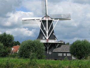
På kanalsejlads i Holland
53° 19′ 51.6972” N 6° 55′ 28.056” E
Efter at have tilbragt et par dage på den tyske ø Norderney sætter vi kurs mod Delfzilj. Byen valgte vi, fordi det herfra er muligt at sejle på kanaler via en såkaldt højmasterute gennem Holland.
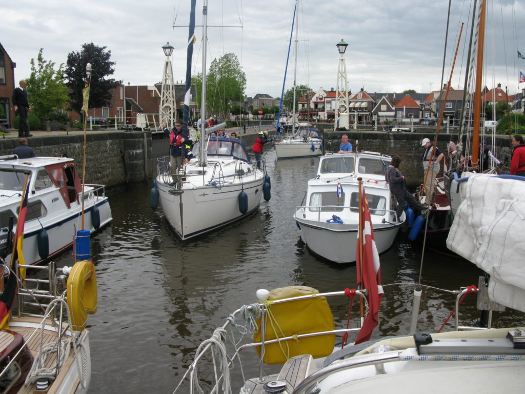
Fem dage – inklusive to overliggerdage – tog det os at sejle fra Delfzilj til Ijselmeer. Vi passerede 49 broer og 5 sluser. Det fungerede perfekt. Broerne går bare op, når vi nærmer os. Som hovedregel. Nogle gange kalder vi via VHF. Ved enkelte broer opkræves der bropenge – 5 euro som lægges i en træsko, der hænger i en fiskestang, som brovagten sænker ned til os.
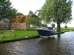
På vores vej passerer vi den ene idylliske hollandske by efter den anden. Husene er placeret med velplejede haver ud mod kanalen. Blomsterne står i fuldt flor, og ved kanten ligger båden fortøjet. Den mest interessante by var dog Groningen.
-
- Every home has a boat
-
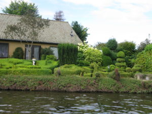
- In Holland you show your best to the waterside
“Er det Ronja? Ronja fra Thurø?”
52° 50′ 33.3672” N 5° 42′ 16.956” E
20. juli, 2012
Fantastisk dag. Alting virker. Broerne åbner sig. Regnen holder tydeligvis lidt igen. Og farvandet er intet mindre end spændende. Tæt trafik. Byer som er arkitekttegnede til at hver bolig har sin båd i forhaven. Kanaler på kryds og tværs. Søer. Store og små. Et virvar af krydsende skibe. Hvis vi troede, Danmark var en sejlernation, så tro om igen. Holland styrer for vildt. Alt handler her om sejlads.
Vi finder en havn. Rolig. Lidt udenfor Lemmer. Går til byen. Spiser i havnens restaurant. Og nyder de mest luksuriøse badefaciliteter. Varmt brusebad i halve timer om ønsket.
Lige før Lemmer passerer vi en dansk sejler, som sejler den modsatte retning af os på kanalen. Stort set alle, vi møder, er hollændere eller tyskere. Men ham her råber: “Er det Ronja? Ronja fra Thurø?” Det viser sig, at de er selv fra Thurø. “Hej med jer!” Og så er de væk.
Alle snakker om vejret. I vores havn er mange tyskere. Snakken går tydeligvis om, at man måske hellere skulle være taget til Mallorca.
Logbog: Afrejse 9.00. Destination: Lemmer. Ankomst: 13.00.

Skænderi med slusevagten. På grund i kanalen
53° 13′ 37.4988” N 5° 49′ 1.452” E
19. juli, 2012
Sort dag. Alt er imod. Vi starter med et skænderi med slusevagten ved Willem Lorésluis. Han lader broen dumpe ned lige foran os. Han synes, vi var for langsomme om at bevæge os frem mod bro og sluse. Vi bebrejder ham, at han kun annoncerer sine budskaber på hollandsk. Vred tale over VHF.
Og sådan går det hele dagen. Vi rammer slusevagternes frokostpause, deres fyraftens-skifte og bruger to-tre timer alene på ventetid. Imens vælter regnen ned og vinden pisker, selv her inde i landet.
Nervepirrende er det, at ekko-loddet konstant viser 10-20-30 centimeter vand under kølen. Og jævnligt 0 centimeter. Ofte – fem gang på en dag – tager vi regulært grunden og står kortvarigt fast. Hollandske kanaler er ikke konstrueret for skibe, der stikker 1,75 meter.
Klokken 19 vil vi ikke mere. Vi fortøjer til en mark med nødtørftigt bolværk og ringe. Sover dybt. En ko muh’er to gange. Et par gæs skræpper. Resten er stilhed. En fortryllende rolig og drømmefyldt nat.
Logbog: Afsejlet: 9.00. Destination: Leuwarden (cirka). Ankomst: 19.00 i Wergea, syd for Leuwarden.

Sur kanalsejlads i regnvejr
53° 19′ 2.676” N 6° 9′ 58.3236” E
18. juli, 2012
Det tager et par timer at komme gennem små ti broer i Groningen. Egentlig ok. Man nærmer sig broen, og den åbner. Som hovedregel. Enkelte gange kalder vi via VHF.
Desværre tager både regn og vind for alvor ved igen og gør turen noget sur. Lejlighedsvist er uvejret så stærkt, at vi gør os fast til kysten, indtil det værste driver over. Vindmåleren viser vindstyrker på 11, 12, 13 og 14 sekundmeter. Især da vi undervejs stikker snuden ud i Waddenzee mærkes vinden dramatisk.
Ved 16-tiden søger vi havn. Stor havn men uden liv. Lunegat. Regnen tager yderligere til.
Logbog: Afsejlet 9.00. Destination: Leuwarden (cirka). Ankomst 16.00 i Jachthaven Lunegat.

Overliggerdag i Groningen. Super
53° 12′ 43.29” N 6° 34′ 13.4616” E
17. juli 2012
Kondiskoene på. Vi bliver i Groningen en ekstra dag og starter med en løbetur rundt Groningens centrale ø, cirka 4 kilometer.
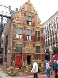
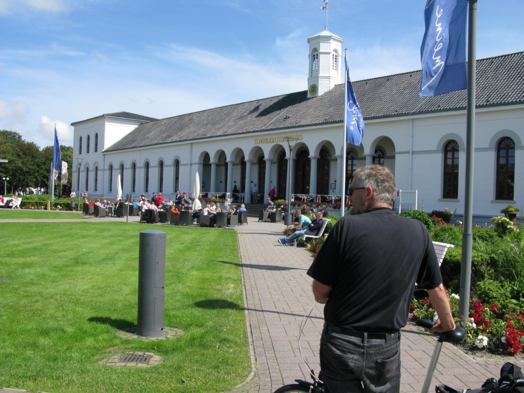
Dagen bruger vi på et fødevaremarked, et skibsfartsmuseum og et fantastisk kunstmuseum. På museet, “Groningen Museum”, bliver vi især begejstrede for en kinesisk installationskunstner, Yin Xinzhen, som får et enkelt kunstværk på samme museum af Wei Wei til at synes fantasiløst og kedeligt.
Selve museumsbygningen er en blanding af skandale og genialt (se billeder).
Vi kontaktede Koos Stall (dygtig hollandsk designer) og hans hustru, Magriet, for at invitere dem på middag på Ronja. Men de var på sommerferie i deres lejlighed i Berlin. De bor ellers kun seks kilomeger fra Groningen. I stedet spiser vi middag på Ni hau, en kinesisk restaurant med fantastisk mad. Irriterende dog at skærme samtidig viser pr-videoer for hele Ni hau-koncernen.
Groningen er en fantastisk by. Ung, vibrerende, energisk, alternativ. Århus gange to. En dansk pige, som studerer på groningens universitet, bekræfter med entusiasme, at det er en mere en almindeligt dejlig by.

Groningen er en vidunderligt varieret by
53° 12′ 43.29” N 6° 34′ 13.4616” E
16. juli 2012
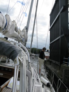
Slusen i Delfzijl sænker os en meter eller halvanen. Foran ligger Ems-kanalen. 26 kilometer snorlige gravet kanal gennem landbrugsland. Logistikken er formidabel. Vi passerer otte broer praktisk talt uden ventetid. Broerne går bare op, når vi nærmer os.
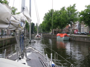
I Groningen svinger vi ind i Oesterhaven, en marina midt i city. For første gang med en formidabel havnemesterinde, der står klar med megafon til at gelejde os ind til rette plads.
Groningen er en vidunderligt varieret by. Gammel og ny. Stor og international. Ung og alternativ. 20.000 universitetsstuderende præger bybilledet. Man fornemmer, at Holland mere reelt end Danmark har været orienteret mod international handel og samkvem. En søfartsnation, der har kanaliseret alle slags folkeslag hjem til Holland og formået (?) at integrere dem. Nå ja, vi ser selvfølgelig kun overfladen.
Skøn by. Her bliver vi en ekstra dag. Der en smule som vores gamle kajplads i Christianshavns kanal. Skibe fra havnerundfarten sejler forbi og forklarer, hvad turisterne ser.
Vejret er det faste. Regn, regn, regn, regn.
Logbog: Afsejlet 10.00. Destination Groningen. Ankomst 13.00. Vejr: Så meget vind, at vi tænker: Godt vi ikke er ude på det åbne havn i dag. Sydvest 11 meter/sekund og opad.

Vi forstår stadig ikke helt tidevandet
53° 19′ 48.864” N 6° 55′ 51.1176” E
15. juli 2012
Op klokken seks. Straks afsted. Vi følger Jörgs råd. Smuk morgen. Sågar med små stykker af blåt og glimt af sol. Men vinden er igen stik imod og bølgerne højere, end vi kender hjemmefra.
Vi ligger mildt sagt uroligt i søen. Der må et sejl op for at stabilisere bådens bevægelser. Per vil gerne gå på dækket og hejse sejlet, men Kirsten insisterer på, at det er hendes job. Hun mener, at chancerne er større for, at Per kan redde hende op af vandet, hvis hun falder i, end for at hun kan redde Per op.
Jörgs tidsplan holder slet ikke. Vi er seks timer om at nå Borkum, ikke fire. Dertil et par timer om at runde denne ø, hvorefter vi komplet misser medstrømmen i Emsen, som skulle have givet os fire ekstra knob i floden ind til Delfzijl.
Emsen-floden er deprimerende trist. Kæmpe store kraftanlæg præger indsejlingen . Og uden andre både på vandet virker her trøstesløst. Dertil gråvejret.
På en “plaat”, som hollænderne kalder de flader, der blotlægges, når tidevandet trækker sig tilbage, ser vi en sæl. Længere henne på samme plaat er en flok turister ved at stige ombord på et skib efter have været på vadehavs-vandring.
Tidevand er et mærkeligt fænomen. Nu har vi sejlet i det i en lille uge, og vi forstår det stadig ikke helt, trods praktiske erfaringer og tonsvis af tidevandstabller.
Men det er ikke længere helt det mysterium, som det var, inden vi satte kølen ud i det for første gang.
Første observation er, at man kan undgå det langt henad vejen. Hvis man bevidst fravælger de områder, der bliver tørlagt, og sørger for, at dybden selv ved lavvande er ok, så handler det alene om mere eller mindre strøm. De halvanden knobs med- eller modstrøm, vi har kendt hjemme i danske Svendborgsund, kan hernede godt blive til fire knobs mod- eller medstrøm. Det kan man forvandle til en fordel, og det kan man forvandle til en ulempe.
Anden observation er, at tilnærmelsesvis sikker viden om den aktuelle status for højvande eller lavvande kan gøre det muligt for dig at passere områder, hvor du ellers ville tænke: “Føj for pokker! Her er ikke dybt nok“. Den rette planlægning giver dig muligheder, som du ellers ville have forsværget. Jörg gav os en kopi af programmet “wxtide47”, som grafisk fortæller dig, hvor du på et givet sted er i tidevandsforløbet.
Tredje observation er, at både tyskere og hollændere har udviklet fantastiske ingeniør-kompetencer i at indrette tidevandshavne, hvor flydebroer ruller op ad kæmpehøje, telefonpæl-agtige stolper, og du kan sove sødt, mens vandet bevæger sig både to, tre, fire eller flere meter op og ned under dig.
Fjerde observation er mere en påstand: Det gør ingenting, at du går på grund, blot tidevandet er med dig, så sætter det dig fri igen. Citat Jörg.
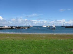
Delfzijl er en ren, uforfalsket industri-by. Men byens marina, Neptunus, er prima. Man sover godt efter 12 timer i de høje bølger.
Logbog: Afsejlet 6.00. Destination: Delfzijl i Holland. Ankomst 18.00. Vejr: Vind fra vest, 10 sekundmeter. Nærmest stik imod vores sejlretning. Store bølger. Megen banken op og ned. Trættende sejlads.

Sådan holder tyskerne kur-ferie
53° 42′ 8.3736” N 7° 9′ 56.6208” E
14. juli, 2013
Vi bliver i Norderney. Løber syv kilometer ind til byen og får en fornemmelse af, hvor vi er havnet.
En kurby. Kæmpe stor. Nærmest en industri. Hundredevis af hoteller og pensionater, parker, caféer og ved vandet kraftfuld natur a’la Vesterhavet i Danmark. Meget net, meget stilfuldt, meget smukt og meget afdæmpet. Sådan holder tyskerne åbenbart kur-ferie.
På båden gør vi rent. Cykler senere ind til byen for at købe ind. Falder i snak med ejeren af nabobåden, Jörg, fra Køln, som har sin Nauticat 33 liggende i Ijselmeer, og som kender tidevandet og de frisiske øer ud og ind.
De gode råd væltede ud af ham. Om tidevand, om kanalsejlads, om vadehavets farer, om mulige byer, hvor vi kunne lægge båden op for vinteren i nærheden af Amsterdam.
Han forærer os nogle søkort, et tidevandsprogram til computeren samt et autokort over hele Holland.
“Tag afsted klokken seks i morgen,” råder han os. Og vi som ellers havde tænkt os at sove længe.

“Hold up” til søs. Politiet border os og giver os en bøde
53° 42′ 8.3748” N 7° 9′ 56.6201” E
13. juli, 2012
Fredag beslutter vi at forlade Helgoland med kurs mod den frisiske ø, Norderney.
Vinden er igen stik imod. Men vejrmeldingen stillede i udsigt, at vinden gradvist vil dreje mod syd og sydøst, og med forventning om dette hejser vi storsejlet i Helgolands forhavn, og så beamer vi ellers afsted for motor med storsejlet som stabiliserende støttesejl parat til at tage over, når vinden drejede.
Det skulle vi ikke have gjort.
Den direkte kurs mod Norderney, bragte os igennem ikke blot ét men to trafiksepareringssystemer, dybvandsruter for store tank- og containerskibe. Ét til floden Jade, ét til floden Elben.
Der var knapt et skib i sigte, dem der var, havde vi styr på, så vi ”skråede” ind over zonen i stedet for at tage den vinkelret. Når en sådan zone er op til 10 km bred, så vinder man både tid og komfort ved at lægge kursen efter vind og mål i stedet for efter reglementet.
Det skulle vi slet ikke have gjort.
Langt ude i horisonten så vi noget, der godt kunne ligne et kystvagtskib. Først da vi så det, slog vi VHF´en til på kanal 16 for at kunne lytte på eventuelle meldinger.
Efter nogen tid så det ud som om, at kystvagten havde sat en mindre båd i vandet, og at den var på vej over mod os.
Fandens også! Der var ingen tvivl. En hurtiggående gummibåd havde direkte kurs mod os. Vi lagde Ronja op i vinden, tog motorkraften af og lod storsejlet blafre stik mod vinden.
Kort efter blev vi anråbt. Fire granvoksne politibetjente i en gummibåd. De lod os forstå, at de ønskede at komme om bord. Meget gemytligt. De jokede ligefrem om, at de trængte til frokost og slog sig på maverne.
Det handlede ikke om frokost. To betjente bordede Ronja. Med pistoler i bæltet og ringbind med formularer og udskrifter under armen.
”Vi vil gerne forklare, hvorfor vi er her”, sagde de. Det vil sige, den ene talte. Den anden noterede. ”Men først vil vi gerne se nogle dokumenter – jeres pas, VHF-tilladelse, skibsførerbeviser, nationalitetsbevis og dokumentation for skibets ejerforhold.”
Heldigvis har vi styr på dokumenterne, og da de efterfølgende spurgte til vores søkort, var der heller ikke noget at komme efter. Alle var fra 2012.
”Vi er her, fordi vi har observeret, at I har krydset en trafikzone i en vinkel, der afviger 30 grader fra søvejsreglerne”, sagde betjenten.
Det havde han fuldstændig ret i. Det vidste vi jo selv, og som om dette ikke var nok, så medbragte han en radarudskrift fra kystvagtskibet, hvor man åbenbart havde fulgt os i længere tid. ”Her er jeres kurs”, fastslog han. ”Vi kaldte jer på VHF kl. 10.32, men I svarede ikke”. Det var før, vi tændte.
Det var den ene ting. Derpå fulgte den anden. ”Vi kan se på kursstabiliteten, at I både har ført sejl og haft motoren på… Det er kun lovligt efter søfartsloven, hvis man med en omvendt kegle hejst halv op i masten viser, at man er et sejlskib, der p.t. fremdrives for motorkraft”.
”Har I en kegle ombord?” spurgte betjenten.
”Jo vist”, svarede Per. ”Den ligger i kistebænken agter”.
”Så må I hejse den op nu”, insisterede betjenten.
”Men kan vi ikke bare stryge sejlet, så vi kun sejler for motor?”
”Jeres beslutning,” lød det fra betjenten. Og ned kom sejlet.
”I har overtrådt to regler. I vil gennem jeres egne myndigheder få et bødeforlæg på to eller tre hundrede Euro”.
Her indskød Kirsten, at så skulle de da hellere sige ja til at få den frokost, som de selv havde foreslået, inden de bordede os. Betjentene lo høfligt og afslog tilbuddet. I det hele taget var de temmelig professionelle. De gik ikke ind i diskussioner, om, hvor vidt der havde været nogen fare eller overhovedet andre skibe i nærheden. De forholdt sig alene til, at en regel var overtrådt.
De hilste pænt farvel og ønskede god rejse, da de steg ombord i gummibåden, der igen var kaldt til.
”Skide tyske bureaukrater”, fnyste Kirsten, da de var på vej væk. ”Det svarer til at få en bøde for at gå over for rødt i en fodgængerovergang midt om natten, efter at have sikret sig, at der absolut ingen trafik er.”
Per var mere afslappet over episoden. ”Vi gjorde noget, vi ikke måtte”. Efter hans mening var det en sjov og interessant oplevelse.
Oplevelsen har bevirket, at Kirsten, hver gang hun ser et fartøj, der ligner et kystbevogtningskib, får nervøse trækninger og spørger Per, om det vi har gang i, nu også er helt lovligt.
Efter næsten 12 timers i øvrigt fin sejlads – efterhånden også for sejl – anløb vi Norderney. De sidste timer af sejladsen var ikke nemme. Vi kunne ikke finde indsejlingsbøjerne, det elektroniske kort sagde ét, vores papirkort noget andet. Men ude i virkelighedens verden var bøjerne der slet ikke. Vi valgte derfor en anden indsejling, “den schluchter” fem sømil længere mod vest.
Logbog: Afsejlet 8.00. Destination: Norderney. Ankomst 17.00.

Vinden hyler. Regnen plasker. Vi tager ekstra dag på Helgoland
54° 10′ 33.3410” N 7° 53′ 38.1156” E
12. juli, 2012
Vinden hyler. Regnen plasker. Vindretningen er stik imod den retning, vi agter os. Vi beslutter at tilbringe dagen på Helgoland.
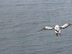
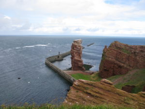
I et hul mellem to byger begiver vi os på vandring øen rundt. Interessant tur. Undervejs forklarer plancher om øens historie. Dramatiske opgør mellem England og Tyskland om ejerskabet til øen. Samtidig ser vi måger, lomvier og en masse andre fugle, som ligger forblæste på hylder i klipperne.
Det er natur, forstås, på den tyske måde. Stier, brolagte med hegn til begge sider og særligt anlagte udsigtssteder. Ikke som på Anholt med fuld frihed til at bevæge sig, hvorhen man lyster.
Men det er alligevel OK. Informativt. Smukt. Vindblæst. Meget anderledes.