
Tidal Seine is rough, desolate and magnificent nature
49° 29′ 39.732” N 0° 6′ 28.5444” E
July 18. – 2013
We had already asked for advice at the port office. “Go at low tide minus two hours,” they told us. Low tide in Le Havre on July 18 is 13.22. Minus two hours is 11.22. As a precaution, we leave at 11.15. It gave us the time for a quiet morning with a long run along the seafront in Le Havre, bath and breakfast.
The two hours before low tide, we use at getting to the entrance of the Seine. In the river there are some scary areas with shallow water, and it was explained to us, that they move from year to year, so as a precaution we have to sail far out into the English Channel before we swing into the entrance to Seine.
It turns out that there are two factors working against us. Today it is neaps. This happens once a month and means that the tidal current is less strong than normal – and therefore we get less co-current flow. At the same time, the wind is strong – 9-11 metres per second – and it slows our speed, as the wind mostly goes against us.
Therefore, we are not reaching today’s goal, Rouen, but have to moor Ronja to an anchor buoy some 15 nautical miles before Rouen as the tidal power is strong, and it becomes impossible to reach our goal within a half hour before sunset, which is the limit for boating on the Seine . We tie up to a very beautiful place.
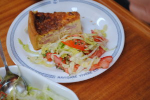
Deciduous trees are all along the riverbank. Direct view of the sunset. Pies, bread and cheese provide an excellent evening meal at about nine.
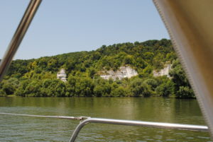
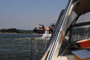
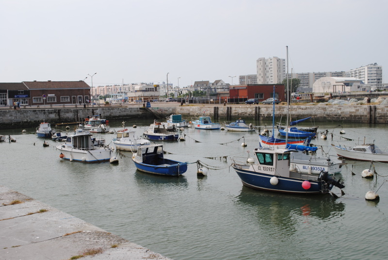
The part of the Seine, which is called the “tidal Seine” is very special. Far more deserted than we had expected. Raw and steep nature. Not a single house has a boat in the front yard, which we have become accustomed to in Holland. In one day we come across less than a handful of boats like ours but maybe a dozen cargo ships. Beautiful scenery alternates with stinking industrial areas. When we are doing the best we log 9.5 knots. But for long periods we have – because of neaps and headwinds – difficulty to exceed six knots.
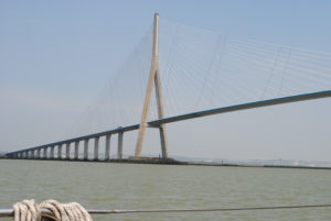
The special feature of the 120 kilometres along the Seine up to Rouen is also, that there are practically no places where you can dock or go to port. The back of the Seine estuary is the town of Honfleur. But then follows more than 50 miles without a single port or anchorage. Deserted. It is a pure coincidence that we find a private anchor buoy, which is free and we have no qualms spending our night in a small town called Duclair.
Log-book: Sailed distance: Close to 60 nautical miles. Time: Departure 11.15 from Le Havre. Arrival 20:30 in Duclair. Weather: Wind up to 11 meters per second from the NNE.

Trend: The further we go south, the higher the price for mooring
49° 55′ 22.7712” N 1° 4′ 38.9388” E
July 17. – 2013
Again, we have problems with the autopilot. We thought that we had solved the problem. But it is still there. In a new form. The autopilot controls the whole game. It is fighting apparently a desperate fight to make the rudder steer a course, that has nothing to do with reality.
Time for the manual again. I hate manuals. We carry out a deviation test by letting “Ronja” sailing around in a circle with two knots – a total round trip of three minutes – while the pilot and the GPS system detects deviation. Then we adjust the indicator again, and we adjust the exchange rate between pilot and GPS as the autopilot consistently believes, that the direction it must follow, is 12 degrees less than what the rest of the GPS system has set.
Several times along the way we think, that we should have a professional Raymarine expert look at the problems. But after some time of experimenting, it seems that we have solved the problem ourselves. And nothing is better than you yourself solving a problem on your own boat.
Today we set sail. Not long. But psychologically it is great to be sailing down through the English Channel.
Le Havre is a large port. For leisure boats it has a huge marina. We walk around the city, we find it difficult to find an absolute centre of the city, but we see many shopping streets, we find a “les halles” market with truly delicious food, and enjoy a beautiful town hall and a theatre house under construction, “Volcan”, which looks like a severed blast furnace from the Ruhr area, and we also take a look inside a church, that looks like a space ship on a launch pad.
It is becoming more and more expensive to moor in a port. In the Netherlands, we paid 11.50 Euro for a night in “Lisse”. We paid 9.30 Euro for an overnight stay in Gouda – beautiful location but not many sanitary facilities. In the City Marina Rotterdam, we paid 27 Euro for a great location and some exceptionally sanitary facilities. In Stichting Veerhaven Rotterdam, we paid 23 Euro for a single button so luxurious accommodation. The Royal Belgian Sailing Club Zeebrugge, Belgium, we paid 28.09 Euro for an overnight stay. In Calais, we paid 23.75 euros per night. In Boulogne-sur-mer, we paid 24 Euros for something that barely was in order. In Port de Dieppe, we paid 30 Euro for a lot of facilities, even though we just used their garbage. And when we arrived at Le Havre, we note that the price has risen to 34 Euro for some services, of which we only used electricity, Internet and water. It is becoming more and more expensive.
It is said that when we reach the Mediterranean, it will get really expensive.
Log-book: Sailed distance: 62 miles. Time: Departure 06.30 from Dieppe. Arrival 14:30 in Le Havre. Weather: Calm, weak sun and tides in our back for the first two thirds of the trip. Then more wind from the northwest, which we tried to take advantage of with the sails.

The boats in the neighbouring basin are on the bottom of a dried-up pool! Talk about tides
50° 57′ 4.645” N 1° 51′ 31.2696” E
July 14. – 2013
The sun shines. It will be a wonderful day. Calais is waiting.
After a few hours at the computer, where Per seeks to resolve a domestic problem at the newspaper, we explore the city. The boats in the neighbouring basin are located on the bottom of the dried-up pool! All the water is gone! Talk about tides.
We see the town hall, which was built in the English style. Calais was for many years in British hands. We rediscover the difference between a boulangerie, patisserie and boucherie. We visit a museum about World War II furnished in a huge German bunker built in the city’s most beautiful park. The bunker has 20 exhibition-rooms with pictures, props and newspaper clippings from the war. An old-fashioned museum concept yet thoughtful because of the subject and the horrific images.
Later, we are on the beach, where the French are getting ready to celebrate the fourteenth of July. It is teeming with bathers, with ice cream parlours, beach toys and promenading Frenchmen. It’s all to get in the holiday mood.
It’s still a little hard with the French. Kirsten’s first order in a cafe was for two coffees – “an espresso and an americano, thank you.” The waiter nods as a sign, that he understands the order and returns with an espresso and a bitter, pink drink called an americano.
During the day we decide to go to sea. We can come in and sail on the canals in time. If we continue along the English Channel and sail up the Seine, there are almost five hundred kilometres to Paris and only six locks. If we go into the channels here from Calais it is 450 km and 36 locks. We choose freedom of the sea. Even if we have to steer by hand all the way if we do not get the chart plotter repaired with its correspondence with the autopilot.
The plan is: Up at 6:30. Out through the port gate for 07:17. And after Kirsten’s increasingly authoritative calculations catch the southbound tidal current at 07:57.
At high tide the boats are in the water. At low tide the same boats are lying at the bottom of the harbour

Vive la France! We are in Calais, France
51° 19′ 8.2092” N 3° 12′ 24.6636” E
July 13. – 2013
The harbour master in Zeebrugge had recommended discharge at low tide, minus two hours, plus 40 minutes to get out of the relatively large but rather dull port of Zeebrugge. Low tide on July 13 was 11.32. That made the departure 9:32 and then forty minutes to get out of the harbour. For safety’s sake we left at 8.30.
Having learned from yesterday, Kirsten set sail already inside the harbour. It did not, however, make a big difference. The English Channel was a mirror. Not a breath of wind.
Still, the day starts with an unpleasant surprise. The chart plotter goes out, and on the screen we see a revived icon of Ronja, revolved 240 degrees the wrong way on the map, which result in the fact that we cannot use the autopilot. Every time we try to do it believes that it is going completely the wrong way and therefore insists on turning the boat 240 degrees.
Sigh! Handheld rudder for eight hours. Not much to steer by. Just digital compass numbers. But the English Channel is nice. Certainly much more beautiful and more ingratiating than its reputation.
Then it’s “Vive La France!” We chug in with the giant ferries from England to the Calais port and immediately we meet a Frenchman who is driving his motorboat around with aggressive and theatrical gestures as he tries to capture a plastic dinghy. Already at the entrance to the port, we do sense a cultural shift.
Welcome to Calais. Tomorrow is Bastille Day. We find a place in the tidal protected waiting basin, and after less than one hour we are let into the inner harbour. We eat leftovers and are pleased to be in France.
Calais has so much to offer. It is an old British city. The City Hall has obvious references to Big Ben in London with a beautiful flower park spread before it. Amid the flowered park is an impressive work of Auguste Rodin, “the six burghers”. When the British had defeated the city in the 1300’s, the English king threatened to liquidate all its inhabitants. Six prominent citizens interceded. A very intense work.
Log-book: Sailed distance: 60 miles with the tide in the back for the first six hours and then tough counter flow a few hours down towards Calais. Time: Departure 09.30 from Zeebrugge. Arrival 17:00 to Calais where we should anchor at a bend in a basin until the bridge is opened into the marina basin. Crew: Kirsten and Per. Weather: North western wind maximum of 5 meters per second. Never has the channel been so flat.
-
- An oldfasioned museum in a bunker, however interesting
-
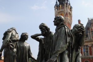
- Auguste Rodin, “The six burghers”.
-
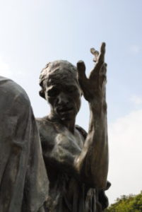
- A very intense work of Rodin.
-
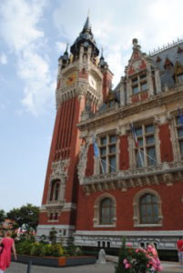
- The City Hall has obvious references to Big Ben in London

Rotterdam the largest port in the world? Likely
51° 54′ 33.7644” N 4° 29′ 57.264” E
12. juli 2013
The exit through the port of Rotterdam is indescribably exciting. Dynamic. Everything is incredibly large. The cranes, docks, tugs and warehouses. Kilometre after kilometre this huge port stretches itself. Through thirty unbroken kilometres side branch follows side branch, docks follows docks, crane follows crane. The largest port in the world? It is likely.
Cargo ships entering. Cargo ships on the way out. Huge. Small. Crawling into and out of the side channels. In the beginning only a few. During the early morning it becomes more. The port awakens. Rotterdam is in the process of getting the day into gear.
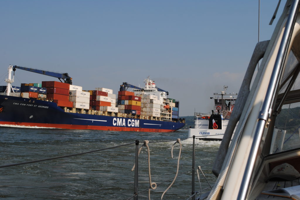
The vessels are sailing in columns on the Maas River to Rotterdam. The day is really waking up. Rotterdam moves up a notch.
We got up at 6:30 and said goodbye to Rotterdam before the clock hit seven. The harbour master in Stifting Verhagen Rotterdam – in combination with our own still a little hesitant calculations – told us that we get the most nudge in the back of the tide, if we start a little before high tide in Rotterdam and capture the southbound tide at the Maas River estuary off the Hoek van Holland. We do. The plan works.
Seven knots and later eight and a half knots, our speed through the English Channel, where we changed to go by sail in stead of motor, while we blissfully eat Kirsten’s homemade muffins with Dutch cheese and Italian sausage, sleeping half an hour alternately and otherwise enjoying a leisurely sail. High speed but completely under control because neither wind nor wave height is scary.
The Dutch have mastered the security of their inland waterway system. We change dutifully channel on VHF each time a sign on the country proclaims, that VHF channels now change to a new number, but we fail to call the station every time we come to a new VHF station, which had been recommended by the harbour master of Rotterdam City Marina. We sail gently. We are in control. Big brother in the Maas River control towers do not hear from us.
On the way out of the Maas exit we get called by a control tower.
“The yacht that just left the harbour entrance please report!”
“Ronja here!”
“Southbound or northbound?”
“Southbound”
“Have you seen the vessel just behind you?”
“Yes, we are intending to cross the traffic-line, just after they pass”
“Two more ships are coming in, please wait and keep to this channel.”
Later, we are contacted again by the control tower and asked to turn to the south, after the last of the two incoming vessels have passed. The vessels are sailing in columns on the deep-water route to the Maas River and Rotterdam. The day is really waking up. Rotterdam moves up a notch, while we have said farewell to a dutch adventure, that has lasted almost a year.
Log-book: Sailed distance: 75 nautical miles with the tide in the back of the Maas River and down to South Holland and Belgium. Time: Departure 6.50 from Rotterdam. In Zeebrugge, Belgium, 17.00. Crew: Kirsten and Per. Weather: North western wind maximum 7 meters per second. Wave height: 1 meter
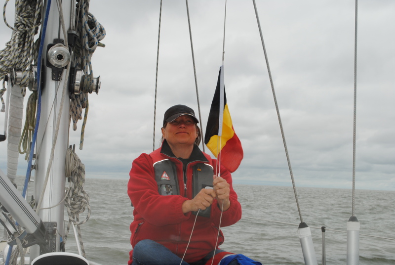
Goodbye Holland. Hello Belgium. Kirsten changes our guest-flag